More on the Storm of 2013 – with Dustin Pedroia

We have a lot of snow here in Boston and the hot discussion is whether the T or train system could have reopened faster – not until tomorrow morning for the Monday commute.  For those of you who don’t know, the train is partially underground and partially above.  I can hear them working on the orange line which runs down the hill from our house and is above ground where we are.  And while our street has been plowed there are places where the wind has blown snow back across it and people are getting stuck.

But Brendan Lynch at public radio WGBH is trying his best to look forward to spring.  He is measuring the snow in Dustin Pedroias.  Dustin is the shortest member of the Red Sox.  I think that Brendan is working on the official Major League height and Dustin is actually shorter, but here is what was posted yesterday morning.  There have been so new totals since then so you can do your own math.

Spencer (which is near Worcester, MA) is now reported at 34.5″  clearly half a Pedroia.  Logan Airport (which will be the official Boston total) is 24.9″   And Jamaica Plain, a section of Boston right across those Orange Line tracks from us, is 25.5″  These totals are from David Epstein’s Weather Wisdon blog.

So while we aren’t quite half a Pedroia here in Boston, that is still a lot of snow!

Highland Park 2-9-2013

Another view of the park across the street.

Snowed in

The blizzard of 2013 is what we are calling it here in Boston.  And it is still snowing.  No cars allowed on the streets and highways, no public transportation.  Because of the blowing snow it is hard to figure exactly how much has fallen, but it is currently in excess of 20 inches and another 5 to 8 may accumulate before it is all finished.  Luckily we didn’t lose power but we are snowed in.  It is also cold currently 20 degrees.

From Boston.com (The paper is not being delivered today.  Also no mail.)

Hundreds of thousands of Massachusetts residents have lost power because of the mammoth blizzard that lashed Massachusetts with hurricane-force winds and dumped more than two feet of snow in some areas overnight.

The state is at a standstill, with residents hunkering down at home under a rare travel ban imposed by the governor on Friday, and the MBTA saying it will not be able to restore service today. Snowplows are out in force struggling to clear the roads, but the storm is expected to continue dumping snow into midday.

National Guard troops are heading to coastal communities to assist in possible evacuations due to giant waves whipped up by the storm that are expected to batter the beaches at high tide at 10 a.m., potentially devouring beaches and homes.

State emergency management officials said there were no reports of major injuries due to the storm, even though there were two truck rollovers and about 30 stranded motorists had to be rescued from the roads.

According to New England Cable News (NECN) the Governor had this to say

Governor Patrick says he’s impressed with the fact there have not been any serious injuries yet as a result of this storm.

“When you consider the scope of the storm and the severity of it, it’s really a minor triumph that we haven’t had serious injuries,” Governor Patrick said. “We had a couple people out last night, I guess, defying the ban and taking their chances, and we had vehicles driving the wrong way on the Pike, on Storrow Drive … but no serious injuries.”

I guess it takes all kinds!

This picture was just posted on Boston.com

This is in the Charlestown section of Boston.

This is in the Charlestown section of Boston.

We have cousins who live in this area of town.  Like where we live, the streets are narrow and winding.

So why was the storm so bad?  Like Hurricane Sandy, two fronts converged over New England.  According to the Boston Globe

The fierce nor’easter that began walloping New England on Friday was the product of two storms that merged, causing a rapidly strengthening storm known in weather jargon as a “meteorological bomb.”

“We just have the right setup,” said Lance Franck, a National Weather Service meteorologist in Taunton. “It really is just a classic snowstorm.”

Forecasters said Friday night the storm remained on track to produce prodigious amounts of snow. But, in many ways, it reflects an utterly typical winter weather pattern, meteorologists said. Its path just happens to be dead-on, landing at a meteorological sweet spot to produce substantial snowfall in New England.

The jet stream that flows from west to east, 18,000 feet above the surface of the Earth, has two branches: a polar stream that takes a northerly route and a second, more southerly stream. When those branches converge, which is a pretty routine event during winter, snow is a possibility, as the frigid air from the north mingles with the humid air from the south.

“This winter has been interesting because the two streams have been largely separate,” Franck said.‘But the process of this happening isn’t unusual, it happens almost every winter.’

Until Friday.

This time, separate storms were brewing in each branch of the jet stream. The storm in the northern branch had deposited light snow in the upper Midwest. The storm in the southern branch had spawned rain in the mid-Atlantic, Franck said.

They separately swept toward New England, and by Friday night, meteorologists were saying the storms appeared destined to combine — very near a spot meteorologists call the “benchmark” because it is a pivotal spot for understanding how storms are likely to behave.

“The intersection point where the storms will ultimately become one . . . just south of Block Island, in that area — that’s just the perfect location,” said David Epstein, a meteorologist whose forecasts appear on Boston.com.

The bottom line is that the two fronts merged at the sweet spot to produce our blizzard.

Here are some pictures I took from the house this morning.

my street

my street

The park across the street

The park across the street

Snow: It seems to be a theme these days

I’m sitting here working on this post and snow is falling.  We are only supposed to get a couple of inches before it turns to freezing rain.  That should make lovely driving.  But snow seems to be on people’s minds.  How much snow will we get?  Will the ski season be a good one?  And how will climate change impact snow?

Mark Vanhoenaker wrote an opinion piece in the New York Times Review yesterday.  He began

SNOW was my first love. From November’s first flakes and the season’s first blizzard, to unexpected midnight dustings and late March blasts, snow fell frequently and happily on my childhood in western Massachusetts. I never complained about the unshoveled, post-blizzard darkness of my paper route, nor about scrambling over icy drifts en route to school. In the evenings I read in front of our wood stove, captivated by thoughts of Narnia’s endless winter.

Snow gives us a new world. It gives us (not least) a day off to contemplate it. Snow bestows silence: deep snowfalls “spread their peace,” said Saint-Exupéry. Above all, snow gives meaning to the great indoors. Thoreau wrote that in winter, “warmth stands for all virtue.”

But, he wonders, will snow go away?

Fortunately, despite worries about a warming planet, no one is predicting the end of snow anytime soon. Some cold places will see more snow, because warmer air can carry more moisture. In the Northern Hemisphere, snow coverage this past December was the greatest since records began in 1966, Rutgers University’s Global Snow Lab reported. But Dr. David Robinson, a climatologist at Rutgers, warns that year-to-year fluctuations and regional differences can deceive casual observers. In general, he says, there has been an “overall decline in snowfall.”

Other studies echo that conclusion. The United States Global Change Research Program’s recently released draft National Climate Assessment reports that “Overall snow cover has decreased in the Northern Hemisphere, due in part to higher temperatures that shorten the time snow spends on the ground.” The report also notes a decline in the frequency of very snowy winters and in snow accumulations in the American West, and said we can expect more rainstorms “in previously snow-dominated settings.” A recent study by the Natural Resources Defense Council warns that without action on climate change, the snow season in the Northeast will be halved by 2100.

That is a long time off and maybe it won’t happen.  Yes, I think that there use to be a lot more of the white stuff.  The first couple of years after I moved to Boston the snowfall total was measured by Robert Parish.  Then one year a few years ago, it was Shaq O’Neal.  We seem to like to measure by Boston Celtic centers.  But  then I saw Zippy this morning.

Zippy snow

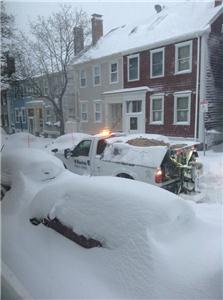
I started thinking about the biggest snowstorm I can remember from my New Jersey childhood and it may be the one from the mid-1950’s.  If Bill Griffith and I are remembering the same storm, it would have still been snowing when they came out of the Museum because the March 1958 storm dropped 11.7 inches on Central Park over several days.

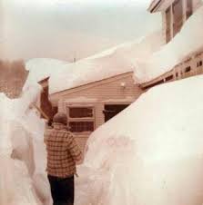
We were living on a small New Jersey farm outside of Philadelphia.  It snowed from March 19 through the 21st.  There wasn’t a lot of warning and it kept snowing and drifting.  I think you could call it a blizzard.  We lost power at some point and it stayed off for at least a week.  The road near our farm looked a little like this.

We did have a small generator and ran the heat and various appliances separately.  I know we had to run the big freezer in the basement often enough to keep things frozen.  We had lots of meat and frozen vegetables.  I think after it stopped snowing, my father may have grilled outside.

We had drifts like this.

There was a path to the chicken house my father and grandfather tried to keep shoveled because the chicken had to be fed and watered.  I think we used the old well and hauled up water in buckets once it stopped snowing.

Looking back is romantic, but I’m sure we were cold, tired of makeshift meals and a little bored.  I still like snow.

Photographs from Google Images of the March 1958 storm

Snowy Boston – Updated


Updated 2-3-2011: 

Here is the new Shaq-o-meter with the addition of Nate Robinson who is buried after yesterday’s snow, sheet, rain mix.

http://www.boston.com/news/weather/graphics/2011_snowfall/?p1=News_links

So how much snow is there?  We have piles at corners.  Snow is taking up a travel lane on many streets where the piles are now extending out into the parking spaces forcing cars to park in the right hand travel lane.  I’m waiting for the day when we have single lane roads and cars yield to each other.  Walking is difficult.  Where the sidewalks are cleared, one can walk, but beware when you have to cross a street.  No wonder people are walking in the streets!

Boston is now at 60.3 inches for the season and counting.  Nothing to do but to have some fun with it all.

We measure the snow level against Shaquille O’Neal.  http://www.boston.com/news/weather/graphics/2011_snowfall/?p1=News_links

In 1995-1996, I think we used Robert Parrish.

And we save our precious parking spaces.  As removed snow takes up more and more space this becomes more and more critical.  Yes, we all know that we technically have 48 hours after the last snowfall before the space saver is in danger of removal and we all know of the person who saves their space long after any trace of snow has disappeared, but right now it is a matter of survival to save the space in front of the house.  It is so bad, I had to tell my sister she had to find somewhere else to stay this weekend because there was no parking for her car.

Boston parking-spot savers

I think this person is cheating because they really didn’t clear the space, but then look at the mound behind the chair.

It is supposed to snow a couple of inches tonight and maybe more next Wednesday.  Shaq is going to be buried before winter ends.