
When I did my first post on the Longfellow Bridge almost four years ago, I didn’t realize it was the first in an occasional series, but that is what it has turned out to be. The first post was about design and reconfiguring the roadway for car, the train, bicycles, and walkers. In the second, I wrote about the final design, the construction schedule and traffic patterns during the long period of rebuilding. And since the construction is now underway, this post is about rebuilding the historic structure.
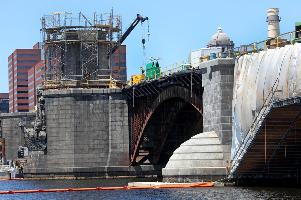
Longfellow Bridge under construction May 2014
I had a chance to look at the bridge the other night when we drove over to Kendall Square on Memorial Drive. You can see the old ironwork and that one pair of the salt and pepper shakers has been removed. So it was interesting to read the story in the Boston Globe a few days later on some of the difficulties engineers and contractors have been confronting.
It turns out that they just don’t make bridges the way they used to.
One year after the launch of the sweeping Longfellow Bridge reconstruction project, contractors are getting an education on the construction practices of yore, poring over century-old bridge building manuals, reviving obsolete metalworking techniques, and scouring the region for building materials that have long disappeared from the market.
Rockport granite, with its inimitable grain? That stuff stopped being excavated during the Great Depression.
And the art of riveting metal? Its heyday — which calls to mind black-and-white photos of fighter planes and posters of a bandanna-wearing woman named “Rosie” — has long faded into the past.
The Longfellow is historic and contractors bidding to work on the bridge were required to agree to replicate old techniques wherever possible. Riveting for example.
The art of riveting went out of fashion a half-century ago. The practice involves heating rivets, cylindrical metal shafts with round heads, up to 2,000 degrees, until they glow bright red, then quickly jamming them into a hole before they have a chance to cool. It’s slow, costly, and dangerous. That’s why construction largely switched to nuts and bolts that can more easily be screwed into place.
“The technology never totally went away,” Sullivan [Charles from the Cambridge Historic Commission] said. “But you no longer see pictures of people standing on the frame of the Empire State Building throwing rivets through the air.”
So how did the contractors learn the technique?
Some of the contractors attended a seminar on riveting in Michigan. Others looked to 1930s-era manuals on rivet techniques — their best guide on the subject.
And the Rockport granite?
But rivets aren’t the only challenge of this project. Finding the right replacement granite has proved elusive.The particular granite hails from quarries in Rockport that began to close just after the Wall Street crash of 1929.
Concrete was cheap and easy to make, and became a more popular option for construction.
Now, Rockport granite is impossible to find freshly cut from the earth: Anything now on the market has been reclaimed, stripped from an existing structure. And most pieces available are thin slabs — not the great big blocks necessary for the work on the Longfellow.
As part of a new design for the bridge deck, contractors had already planned to strip the existing granite curb between the vehicle lanes and the T tracks. They had hoped to repurpose that granite to construct new stone stairs and barriers on the side of the bridge.
…
But the stone alongside the train tracks is known as Deer Isle granite, which has a lavender hue — not the black-white-and-gray speckled look of Rockport granite.
“People who know stone said, ‘Oh, it’s Deer Isle, that’s not going to work,’ ” Roper [Steve from Mass DOT] said. “They’re different grains, and they will not look good if you put them side by side.”
So where can you find Rockport granite?
What they didn’t know: Biz Reed, co-owner and executive vice president of Wakefield-based Olde New England Granite, had exactly what they needed. In 2010, on a whim, Reed’s company had purchased 3,000 tons of historic Rockport granite that had been stripped from the Hines Memorial Bridge in Amesbury during a reconstruction project.
He had no idea what the company would do with such a large amount of such a particular form of stone, but they couldn’t pass it up.
“Little did we know it would be the right match for the Longfellow,” Reed said. “We just happened to be in the right place at the right time.”
When Reed got word that a team of MassDOT officials, historical preservationists, and construction contractors were all on the hunt for the Rockport stone, he gave them a call.
So piece by piece, rivet by rivet, the Longfellow Bridge is being restored to her former self – with room to ride, walk or bike.

Photograph: Longfellow under construction David L. Ryan/Globe Staff
Photograph: Longfellow Bridge from Wikipedia images


