
The blizzard of 2013 is what we are calling it here in Boston. And it is still snowing. No cars allowed on the streets and highways, no public transportation. Because of the blowing snow it is hard to figure exactly how much has fallen, but it is currently in excess of 20 inches and another 5 to 8 may accumulate before it is all finished. Luckily we didn’t lose power but we are snowed in. It is also cold currently 20 degrees.
From Boston.com (The paper is not being delivered today. Also no mail.)
Hundreds of thousands of Massachusetts residents have lost power because of the mammoth blizzard that lashed Massachusetts with hurricane-force winds and dumped more than two feet of snow in some areas overnight.
The state is at a standstill, with residents hunkering down at home under a rare travel ban imposed by the governor on Friday, and the MBTA saying it will not be able to restore service today. Snowplows are out in force struggling to clear the roads, but the storm is expected to continue dumping snow into midday.
National Guard troops are heading to coastal communities to assist in possible evacuations due to giant waves whipped up by the storm that are expected to batter the beaches at high tide at 10 a.m., potentially devouring beaches and homes.
State emergency management officials said there were no reports of major injuries due to the storm, even though there were two truck rollovers and about 30 stranded motorists had to be rescued from the roads.
According to New England Cable News (NECN) the Governor had this to say
Governor Patrick says he’s impressed with the fact there have not been any serious injuries yet as a result of this storm.
“When you consider the scope of the storm and the severity of it, it’s really a minor triumph that we haven’t had serious injuries,” Governor Patrick said. “We had a couple people out last night, I guess, defying the ban and taking their chances, and we had vehicles driving the wrong way on the Pike, on Storrow Drive … but no serious injuries.”
I guess it takes all kinds!
This picture was just posted on Boston.com
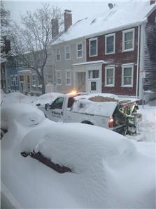
This is in the Charlestown section of Boston.
We have cousins who live in this area of town. Like where we live, the streets are narrow and winding.
So why was the storm so bad? Like Hurricane Sandy, two fronts converged over New England. According to the Boston Globe
The fierce nor’easter that began walloping New England on Friday was the product of two storms that merged, causing a rapidly strengthening storm known in weather jargon as a “meteorological bomb.”
“We just have the right setup,” said Lance Franck, a National Weather Service meteorologist in Taunton. “It really is just a classic snowstorm.”
Forecasters said Friday night the storm remained on track to produce prodigious amounts of snow. But, in many ways, it reflects an utterly typical winter weather pattern, meteorologists said. Its path just happens to be dead-on, landing at a meteorological sweet spot to produce substantial snowfall in New England.
The jet stream that flows from west to east, 18,000 feet above the surface of the Earth, has two branches: a polar stream that takes a northerly route and a second, more southerly stream. When those branches converge, which is a pretty routine event during winter, snow is a possibility, as the frigid air from the north mingles with the humid air from the south.
“This winter has been interesting because the two streams have been largely separate,” Franck said.‘But the process of this happening isn’t unusual, it happens almost every winter.’
Until Friday.
This time, separate storms were brewing in each branch of the jet stream. The storm in the northern branch had deposited light snow in the upper Midwest. The storm in the southern branch had spawned rain in the mid-Atlantic, Franck said.
They separately swept toward New England, and by Friday night, meteorologists were saying the storms appeared destined to combine — very near a spot meteorologists call the “benchmark” because it is a pivotal spot for understanding how storms are likely to behave.
“The intersection point where the storms will ultimately become one . . . just south of Block Island, in that area — that’s just the perfect location,” said David Epstein, a meteorologist whose forecasts appear on Boston.com.
The bottom line is that the two fronts merged at the sweet spot to produce our blizzard.
Here are some pictures I took from the house this morning.
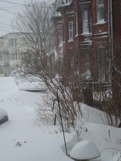
my street

The park across the street
Related articles
- Storms carried by two branches of the jet stream converge to spark nor’easter (boston.com)
- New England, all the way (boston.com)
- Blizzard of ’78: Being There (wjla.com)
